(from the June 2007 SHAF Newsletter)
by Ranger Mannie Gentile
As we all know relic hunting is strictly prohibited at Antietam National Battlefield. As a visitor this is a rule that I always followed and now, as a ranger its something that I help enforce. Imagine my surprise, then, as I found myself, in mid-January, actively seeking out a particular relic on park property.
The relic I was hunting was a view.
Over the course of 2006 plans were implemented to open three new interpretive trails at the park: a Sunken Road trail, West Woods Trail, and the Union Advance Trail. The Union Advance Trail focuses on the Ninth Corps’ efforts to get across Antietam Creek and the storming of Burnside Bridge.
This part of the battle has always been interpreted from a Confederate perspective, which is quite logical considering that from the bridge parking lot the view is from the Confederate position. The quarry pits used as rifle pits by the Confederates are at the visitor’s feet and a commanding view is provided of both the bridge below and the heights beyond. Those heights beyond are the Union positions and have always generally been merely the visitor’s view rather than the visitor’s experience. With the new trail a broader and richer story will be available to the visitor. Now a trail will follow the ridge opposite the bridge on the Union side of the creek to reveal a vantage point of the bridge lost for generations. This was the vantage point I was hunting as I climbed the steep face of that hill along the viewshed recently cut by the park’s natural resources department.
From the base of the hill I saw a rock outcropping about half way up. As I climbed toward it, with the bridge behind me, the outcropping revealed itself as a stone quarry, doubtless used during construction of the bridge. Gaining that quarry pit provided a nice breather as it is the only flat place on that slope. Flat enough for, say, a tripod?
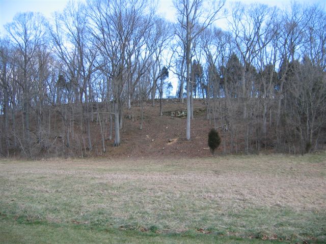
2007 View of Gardener’s Photo Site – Courtesy of Mannie Gentile
Even before I turned around I knew what I’d be seeing. This must be the spot from which Alexander Gardner captured this since long-lost view of the bridge.
A little background:
This new trail was the undertaking of interpretive rangers Keith Snyder, Brian Baracz and chief ranger Ed Wenschhof. I asked Keith and Brian if that Gardner view was something they were trying to restore. “Not initially” responded Keith. “We were mostly interested in providing the visitors with a glimpse of the difficult position that the Ninth Corps found itself in.” Brian added “It wasn’t until we discovered that quarry pit that we realized we’d come across Gardner’s vantage point, from there we looked through the brush, toward the bridge, and there it was”.
The “it” was that historic view, long lost, now regained. Back on the slope of the hill I turned from the quarry pit, camera in hand, toward the bridge, and there before me, this time in full color, was Gardner’s historic image of the bridge. A relic retrieved and available to park visitors this April.
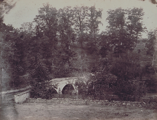
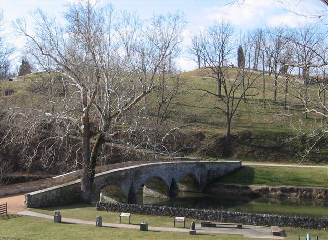 1862 View – Courtesy of Alexander Gardner 2007 View – Courtesy of Mannie Gentile
Come see for yourself.